On Thursday, November 11, my seven year old son and I joined the Sacramento Hiking Meeting for a five mile hike in the dark along the Cardiac Bypass Trail. This is in the Auburn State recreation Area. It probably has some nice views of the river, but it was really dark.
The map below isn't the exact route, but it must have been similar.
Saturday, December 11, 2010
Sunday, November 21, 2010
Sutter Buttes Summit Ascent
I climbed the Sutter Buttes - North Butte summit on Sunday, November 21. This can only be done as a guided hike from the Middle Mountain Foundation.
Their description was as follows.
I didn't find this too challenging, we climbed the summit in about a half hour, but it took 90 minutes from the start of the hike to get there. Our guide stopped every few hundred feet to speak out the natural history of the place. Once we got to the top were were warned of the danger of climbing the craggy rock that represents the top. I was a little disappointed. however, the view was spectacular.
Their description was as follows.
One of our most challenging treks, this route is a steep, 1,000-foot push straight up North Butte; off trail with no easy switchbacks. Only register for this hike if you are in very good physical shape and don’t suffer from vertigo. Bring food and water. Limit is 15.
I didn't find this too challenging, we climbed the summit in about a half hour, but it took 90 minutes from the start of the hike to get there. Our guide stopped every few hundred feet to speak out the natural history of the place. Once we got to the top were were warned of the danger of climbing the craggy rock that represents the top. I was a little disappointed. however, the view was spectacular.
 |
| A model of the mountain in the Yuba City museum seems a bit exaggerated. |
 |
| The peak seems less intimidating from a distance. |
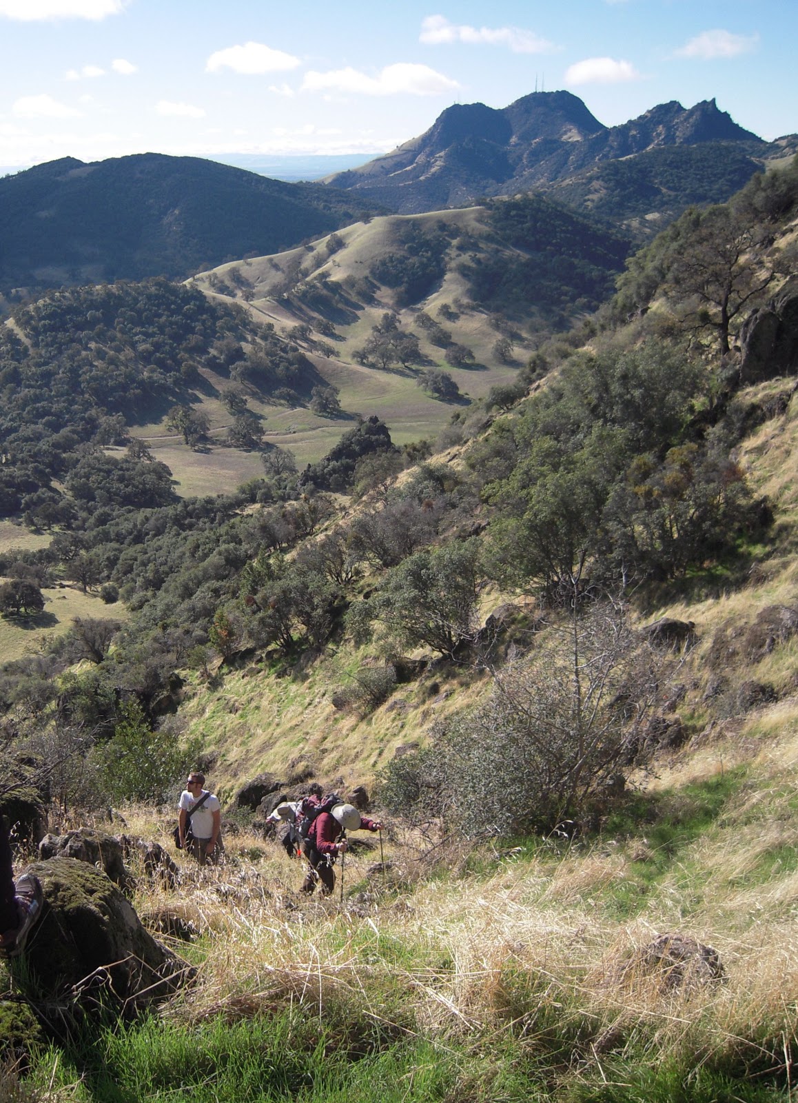 |
| On the climb up. The South Buttes are seen in the background. Becuase they have radio, TV and cell towers,public access is prohibited. |
 |
| Looking down on the valley that is now state park land. |
Wednesday, October 6, 2010
Carpenter Benchmark- Highest Point in Sacramento County
On Sunday, October 3, my 12 year old and I joined a Sacramento Hiking Meetup to the highest point in Sacramento County, the Carpenter Benchmark (828 feet above sea level). The leader of the hike planned a route that included million dollar views as we walked the streets of million dollar houses in Folsom.
One member of the hike published this Google Earth look at the route.
One member of the hike published this Google Earth look at the route.
 |
| Hikers on their way to the top, next to cell towers |
 |
| A view at sunset with downtown Sacramento on the horizon. |
Sunday, October 3, 2010
My Review of Marmot Titan Backpacking Tent - 3-Person, 3-Season
Originally submitted at Sierra Trading Post

Closeouts . Ventilation, ventilation, and more ventilation. Marmot's Titan backpacking tent is mostly mesh under the weatherproof fly, to keep you exceptionally cool in hot weather and eliminate tent condensation when the mercury drops. Its light weight makes it perfect for casual weekend backp...
A great buy
By digihiker from Sacramento on 10/3/2010
Pros: Easy To Set Up
Best Uses: Backyard, Car Camping, Backpacking
Describe Yourself: Casual/ Recreational
What Is Your Gear Style: Minimalist
Was this a gift?: No
This was a great buy. I saved a couple hundred bucks compared to Marmot's Limelight model. The main difference is that the body of the tent is netting, much like Big Agnes Seed Tent. Unlike the Limelight, this model does not include a footprint or gear loft. I bought a Tyvek sheet for a footprint. Quick and easy to set up.
(legalese)
Sunday, September 26, 2010
Horsetail Falls to Ropi Lake in the Desolation Wilderness
On Sunday, Septmebr 26, 2010, I hiked Horsetail Falls to Ropi Lake in the Desolation Wilderness. I did this with the Sacramento Hiking Meetup Group. I went with five others. The hike was about eight miles, round trip.
View Larger Map
The trail head is just past Strawberry about an hour and a half from Sacramento. The trail is in the El Dorado National Forest. Pyramid Creek Trailhead is located at Twin Bridges. The Forest Service has a has a parking lot with a fee of $5.00. Pit toilets and water are available. We arrived at about 8:30 and hit the trail at 8:45 a.m. The trail is initially easy.
At the farthest end of the loop, you will find the tail into the Desolation Wilderness. Filled out the permit for your group and head up trail. This trial becomes harder to follow.
Eventually we guessed which way to go and followed the creek. It becomes a scramble to the top. This is a good workout and the rock is slick in some sections. After the long scramble, hike is easier to the lake. The weather was a surprisingly warm, 90 in Strawberry, but with a slight breeze is was a beautiful day for a hike.
We spent about an hour at the lake. We returned to the parking lot at 2:30. The drive home slowed to a crawl for some reason around Placerville.
View Larger Map
 |
| Pyramid Creek Trailhead map. |
At the farthest end of the loop, you will find the tail into the Desolation Wilderness. Filled out the permit for your group and head up trail. This trial becomes harder to follow.
Eventually we guessed which way to go and followed the creek. It becomes a scramble to the top. This is a good workout and the rock is slick in some sections. After the long scramble, hike is easier to the lake. The weather was a surprisingly warm, 90 in Strawberry, but with a slight breeze is was a beautiful day for a hike.
We spent about an hour at the lake. We returned to the parking lot at 2:30. The drive home slowed to a crawl for some reason around Placerville.
 |
| Top of Horsetail Falls. |
 |
| Horsetail Falls from a distance. |
 |
| Horsetail Falls near top |
 |
| The water on its way to the falls. |
 |
| Water before the falls. |
 |
| Ropi Lake. |
 |
| Another view of Ropi Lake. |
Sunday, September 5, 2010
Grouse Ridge Lookout
On Saturday, September 5, 2010, I did the Grouse Ridge hike with the Sacramento Trail Mix Hiking Meetup. This is located about a two hour drive from Sacramento in the Tahoe National Forest. The hike takes you around a number of lakes and follows some old mining trails. The end point of the hike is a visit to the Grouse Ridge Lookout. This Forest Service fire lookout was built in 1923, but has been vacant and vandalized since the 1970s. You cannot go into the building, but that may change as a group is looking into restoring the building. You can walk around the balcony, which was quite windy. The Lookout provides a beautiful vista at an elevation of 7707 feet.
 |
| Island Lake from the Grouse Ridge Trail. |
 |
| A view from Grouse Ridge. |
 |
| The Trail up to Grouse Ridge Lookout |
 |
| Outhouse at the end of the world (or at least Grouse Ridge.) |
Someone in the group posted this video of the trip.
Sunday, August 22, 2010
Old Sacramento Undergound Tour
I did the Old Sacramento Underground Tour led by the Historic Old Sacramento Foundation on Saturday, August 21. In the early 1980s, I took an archeology course that dug underneath the the concrete slab of a building in Old Sac. It was fascinating to find numerous artifacts buried at this site and to handle something that hadn't been seen in over 100 years. Needless to say, when I learned about this tour, I was excited about it.
I bought the tickets online. While I could have purchased them at the door, they often sell out early on the weekends and I wanted to guarantee our spots on the tour. I found the cost a bit high. $15 for adults and $10 for kids ages 6-17. When you buy them online you are charged a "convenience fee" of $2.25 for each ticket. A family of four will pay $59.00 for a 55 minute tour. The price did not include admission to the museum, which is $3.00 each. New total price $71.00. The museum is a worthwhile add-on. We only had a half hour to check out the place before it closed, 45 to 60 minutes would have been better. You must also include the cost of parking, which will run another five to ten bucks depending on how long you spend in Old Town. The museum sells a very nice 30 page "Official Souvenir Guide" about the tour for an additional $14.95, which I bought. So, a family of four could spend $95 for a two-hour history review of Sacramento.
We met at the Sacramento History Museum. The twenty tour participants were given green hardhats and a headset with a radio receiver that is worn around the neck. The headset did not give any prerecorded information, but was used exclusively to amplify the tour guide's voice. This worked well, and I am sure puts less strain on the vocal cords of the guide. From the museum we walked to the Eagle Theater and watched a video that provided background information. Basically, after particularly devastating flood in 1862, it was decided that the city would be raised an average of 9 1/2 feet. The tour highlights the subterranean spaces below the sidewalks. According to the tour guide there never was a network of connected tunnels, because tunnels crossing the streets were never built, as the cost for raising each building was the responsibility of the individual owners.
I enjoyed the tour and I thought the guide was was energetic. I also learned some things. I would recommend it to others interested in Sacramento's history...if you are prepared to pay for it.
 |
| 1930s era photo show passages under sidewalk |
I bought the tickets online. While I could have purchased them at the door, they often sell out early on the weekends and I wanted to guarantee our spots on the tour. I found the cost a bit high. $15 for adults and $10 for kids ages 6-17. When you buy them online you are charged a "convenience fee" of $2.25 for each ticket. A family of four will pay $59.00 for a 55 minute tour. The price did not include admission to the museum, which is $3.00 each. New total price $71.00. The museum is a worthwhile add-on. We only had a half hour to check out the place before it closed, 45 to 60 minutes would have been better. You must also include the cost of parking, which will run another five to ten bucks depending on how long you spend in Old Town. The museum sells a very nice 30 page "Official Souvenir Guide" about the tour for an additional $14.95, which I bought. So, a family of four could spend $95 for a two-hour history review of Sacramento.
 |
| The helmeted tour group head to the Eagle Theater in Old Sac. |
I enjoyed the tour and I thought the guide was was energetic. I also learned some things. I would recommend it to others interested in Sacramento's history...if you are prepared to pay for it.
 |
| An old archeology pit under a building |
 |
| Tour guide demonstrates house jack. |
Sunday, August 15, 2010
Lower American River Rafting
On Wednesday, August 11, I took the two kids rafting down the Lower American River. We selected River Rat as the company we rented the raft from. There are basically two companies that service this stretch of the American River: River Rat Raft & Bike and American River Raft Rentals. They both start at the same place, but River Rat has a bit longer route, adding about an additional 45 minutes to the trip.
We rented a four person raft for $50.00. We also paid $4.00 per person for the return shuttle fee. Additionally, we paid a required county parks boat launch fee of $2.50, plus a optional raft damage waiver of $2.00.
After renting the raft, we were told we could walk it down an "eight of a mile," or place the raft on the car room and drive it down. We chose the latter. It is a good thing, because it seemed like it was a much longer road than they suggested. It was pretty easy driving the raft down, even though only gravity held it onto the car roof. I ended up parking in the county parking lot for another $5.00. We then had to carry the raft to the water.
The day was not in the mid 80s, and was quite pleasant. We were told that the trip would last about 3 hours, but it was really four and a half. We made a stop of about 20 minutes to a small island about halfway down to stretch our legs.
 |
| A stop on the Lower American River. |
Saturday, August 14, 2010
Alcatraz Island - Golden Gate Bridge
Spent the day in San Francisco with the kids on Tuesday, August 10. We left Sacramento at 9:15 a.m. and arrived in S.F at 11:15 a.m. We parked in the Pier 39 Parking lot. We walked a couple of blocks and had lunch at Rain Forest Cafe. We then walked over to Pier 33 to board the Alcatraz boat.
Our 1:10 p.m. departure time required us to be in line at 12:40 p.m. It takes a bout 12 minutes to get to the island. I made my reservation about two weeks before our midweek trip. I would assume a weekend trip would require an earlier reservation. The price for an adult and junior ticket is $26.00 A child's ticket is $16.00.
After getting off the boat, a ranger gives a short orientation. A hike up the hill through the old brick military barracks leads up the the prison. In the shower room you can collect an headset for the audio tour.
This tour is worthwhile. Last time I was here they had a ranger give the tour, the headsets allow them to put more people through the island.
We took the 4:20 boat back. About 4:40 we had diner at the hard Rock Cafe on Pier 39.
We then drove to the Golden Gate Bridge. It took us about 55 minutes to walk up and back. It was pretty windy and cold. We got back to the car at 8:00 p.m. We were back home at about 10:30 p.m.
 |
| Approaching Alcatraz from the ship |
Our 1:10 p.m. departure time required us to be in line at 12:40 p.m. It takes a bout 12 minutes to get to the island. I made my reservation about two weeks before our midweek trip. I would assume a weekend trip would require an earlier reservation. The price for an adult and junior ticket is $26.00 A child's ticket is $16.00.
After getting off the boat, a ranger gives a short orientation. A hike up the hill through the old brick military barracks leads up the the prison. In the shower room you can collect an headset for the audio tour.
This tour is worthwhile. Last time I was here they had a ranger give the tour, the headsets allow them to put more people through the island.
 |
| Ruins of the warden's house. |
We took the 4:20 boat back. About 4:40 we had diner at the hard Rock Cafe on Pier 39.
 |
| A cell with hole from 1961 escape. |
 |
| Alcatraz cell block |
 |
| Golden Gate Bridge (allow about a hour to hike back and forth) |
Saturday, August 7, 2010
Half Dome - Yosemite
I climbed Half Dome in Yosemite with N.M. on Tuesday, August 3, 2010. All of the hikes this summer were conditioning exercises leading to this experience.
We left Sacramento at noon on Monday and arrived in Curry Village about 3:15 p.m. I selected this accommodation based on the recommendation of "Mr. Half Dome" Rick Deutsch. I attended a Half Dome presentation he made at REI and bought his book, which I found very valuable. Check out his website for some interesting resources.
On April 7, 2010, I made online reservations for a tent cabin in Curry Village. I was able to obtain a Curry Signature Tent for a total of two nights for $292.82.
The Signature Tent is a heated tent during the winter. It has wooden walls, and three windows and a door. It had one double and two twin beds, which included towels, pillows, sheets and a wool blanket. It also has a metal shelf with a digital safe. The sheets and blanket felt crisp and clean. The towels were small and course, but clean. The metal bed frame was a bit squeaky and short for my 6' 2" size.
No cooking is permitted and all food must be stored in the bear locker outside of each tent. Upon checking in, you are provided a key to unlock the padlock on the door of the tent. You must bring your own lock if you want to keep humans out of your bear locker. We didn't bring one, but didn't have any problem with theft. We didn't even hear a bear come through the camp at night.
The big problem with this camp is the rocky gravel they have as ground cover. I am sure it eliminates the mud problem when it is wet, but at night, you can hear your neighbors making their way to the bathroom in the middle of the night.
These tents have a single electrical outlet. I used one to to charge my iPhone and used its alarm to wake us up at 5:15 a.m. I had a quick breakfast of a Clif Bar and a banana. We drove the car a short distance to the trail head parking lot and then walked about a half mile to the trail-head.
It was about 6:15 a.m. and we had hoped to start at 6:00 a couple of minutes after the sunrise. After we had gone up a way, I realized I forgot my trekking pole. I left my hiking partner to wait as I raced back to the car to get it. By the time I got back it was about 6:45 a.m. The little diversion added an extra mile to my hike.
The trail to the base of Vernal Fall has a smooth asphalt surface. The next leg of the trail becomes a bit rougher, but as throughout this trail, significant work was put into building this trail. This includes a granite staircase up to the top of the fall.
People has been swept over this fall while soaking their feet, so there is a hand rail at the top near the water.
The next leg of the hike took us near Nevada Fall. We walked over this on our return, but could see it from a distance. We got a little closer than most when we apparently took a side trail that fortunately rejoined the main trail.
 |
| A view of Half Dome. |
We left Sacramento at noon on Monday and arrived in Curry Village about 3:15 p.m. I selected this accommodation based on the recommendation of "Mr. Half Dome" Rick Deutsch. I attended a Half Dome presentation he made at REI and bought his book, which I found very valuable. Check out his website for some interesting resources.
On April 7, 2010, I made online reservations for a tent cabin in Curry Village. I was able to obtain a Curry Signature Tent for a total of two nights for $292.82.
 |
| Curry Village Signature Tent with bear box. |
The Signature Tent is a heated tent during the winter. It has wooden walls, and three windows and a door. It had one double and two twin beds, which included towels, pillows, sheets and a wool blanket. It also has a metal shelf with a digital safe. The sheets and blanket felt crisp and clean. The towels were small and course, but clean. The metal bed frame was a bit squeaky and short for my 6' 2" size.
 |
| The interior of a Signature Tent. |
 |
| Half Dome at sunset from Curry Village. |
No cooking is permitted and all food must be stored in the bear locker outside of each tent. Upon checking in, you are provided a key to unlock the padlock on the door of the tent. You must bring your own lock if you want to keep humans out of your bear locker. We didn't bring one, but didn't have any problem with theft. We didn't even hear a bear come through the camp at night.
The big problem with this camp is the rocky gravel they have as ground cover. I am sure it eliminates the mud problem when it is wet, but at night, you can hear your neighbors making their way to the bathroom in the middle of the night.
These tents have a single electrical outlet. I used one to to charge my iPhone and used its alarm to wake us up at 5:15 a.m. I had a quick breakfast of a Clif Bar and a banana. We drove the car a short distance to the trail head parking lot and then walked about a half mile to the trail-head.
It was about 6:15 a.m. and we had hoped to start at 6:00 a couple of minutes after the sunrise. After we had gone up a way, I realized I forgot my trekking pole. I left my hiking partner to wait as I raced back to the car to get it. By the time I got back it was about 6:45 a.m. The little diversion added an extra mile to my hike.
 |
| Trail-head sign. |
The trail to the base of Vernal Fall has a smooth asphalt surface. The next leg of the trail becomes a bit rougher, but as throughout this trail, significant work was put into building this trail. This includes a granite staircase up to the top of the fall.
People has been swept over this fall while soaking their feet, so there is a hand rail at the top near the water.
The next leg of the hike took us near Nevada Fall. We walked over this on our return, but could see it from a distance. We got a little closer than most when we apparently took a side trail that fortunately rejoined the main trail.
 |
| Nevada Fall (from side trail). |
 |
| Mist Trail granite staircase up to Vernal Fall. |
Monday, July 26, 2010
Mt. Tallac - South Lake Tahoe
 |
| Gloomy clouds move over Mt. Tallac. |
The forecast called for thunderstorms and a chance of precipitation starting at 11:00.m. About a half hour after we hit the trail we heard thunder, which became steady for the next hour. We felt some light sprinkles and decided to put on our windbreakers. The trail starts by paralleling Fallen Leaf Lake. It then passes Floating Island Lake, which gets its name from odd floating tufts of grass. The lake was very shallow and pretty stagnant, covered in pollen.
 |
| Floating Island Lake with floating grass. |
I thought we might have to turn around when we got to Cathedral Lake, but we decided to take our chances with the weather and head up the mountain. Fortunately, the storm move away from Tallac and by 1:00 p.m. the weather was good.
 |
| Looking down from the summit. |
We ate dinner at the Beacon Restaurant about a mile away from the trailhead in Camp Richardson. We heard two songs before the live band ended their show at 6:00. The food was good and we were back in Sacramento by 8:55 p.m.
 |
| One of the marmots at the summit. |
Water: 4 liters total.
2 - Nalgene liter. One refill up and another back
 |
| Rock shelter built below summit. |
Friday, July 23, 2010
Mt. Roundtop
Hiked to the peak of Roundtop Mountain in the Eldorado National Forest on Friday, July 23. The trailhead parking lot has a small volunteer built and staffed visitor's center. We had excellent weather. A bit of snow remained around th mountain, but did not obscure the trail. The elevation gain seems minimal as you approach the mountain. The trail was easy to follow until you get make the diversion to the peak. There is not an official trail to the top, but by climbing up the saddle between the Two Sisters, we did find a route. At the top you need to use both hands to scramble up the rock.
Water: Carried two liters of water. Refilled one liter after coming down the mountain in stream.
Time: 4.5 hours up and back.
 | |
| Wildflowers with Roundtop in the background. |
Water: Carried two liters of water. Refilled one liter after coming down the mountain in stream.
Time: 4.5 hours up and back.
 |
| A view from Winnemucca Lake. |
 |
| Climbing to the peak |
 |
| Near the "false peak." |
Wednesday, July 14, 2010
Crocker Park to Discovery Park
Did the Sacramento Hiking Group Meetup from Crocker Park to Discovery Park and then across the Tower Bridge to West Sacramento's Riverwalk Park, where we listened to the the Mighty Delta Roadmasters. (They were really good!) I took my seven-year old along and he enjoyed both the hike and the music.
This is a 4.13 mile walk that takes you to the point where the American River meets the Sacramento River. It is a nice mid-week walk. You may come across some homeless people on this walk, but the bike path is traveled pretty regularly by people, so it should be safe. Even so, walking with others may make some people feel more comfortable.
Park your car at Crocker Park (parking is free after 6:00 p.m. and free on Sunday). Walk across overpass (over I-5). Follow sidewalk. To avoid crossing the street at the I Street bridge, take the walkway under the bridge to the moored boats. Walk through Old Sacramento to the end of the Railroad Museum. Follow the bike path to Discovery Park. Cross the Jiboom Street Bridge to cross the American River. Return following the same route.

A shot of the Tower Bridge from the West Sacramento side of the river.
Saturday, July 10, 2010
Lake Tahoe - Fallen Leaf Lake
We spent three days camping at Fallen Leaf Lake campground in South Lake Tahoe.
We did a two-hour horseback ride to Fallen Leaf Lake.
We did a two-hour horseback ride to Fallen Leaf Lake.
 |
| Horseback riding to Fallen Leaf Lake. |
 |
| Creek exhibit |
Convict Lake Horseback Trail
While staying at Mammoth Lakes, we rode horseback on a trail that took us almost halfway around Convict Lake. This was a two-hour ride with a $60 fee.
Thursday, July 8, 2010
Yosemite - Dead Giant Tunnel Tree
While driving from Mammoth Lakes through the Tioga Pass, we stopped in Toulamne Grove and did the trail that leads to a grove of Giant Sequoias and the famous Dead Giant, the first "tunnel tree." The trail is a now closed road. The hike is two miles up and back with a 400' elevation. The Tunnel Tree was hollowed out in 1878.

CathedralGrove.eu has some interesting information about this tree.
YosemiteHikes.com has this map.

CathedralGrove.eu has some interesting information about this tree.
The "Dead Giant" is a famous Sequoia stump located on the first stage road into Yosemite Valley, in the Tuolumne Grove of what is now Yosemite National Park. The veteran Sequoia tree had been struck by lightening but was still living when she was cut down at 90 ft from the ground and debarked. Tunneled c. 1875 to entice stagecoach tourists from San Francisco, this was the first of California's "Drive Thru" trees - macabre roadside displays created to provide entertainment and recreation.
YosemiteHikes.com has this map.
Wednesday, July 7, 2010
Mono Lake
While staying at mammoth Lakes, we drove 40 minutes to Mono Lake. We hiked the South Shore to Navy Beach trail.
Mammoth Lakes - Devil's Postpile to Rainbow Falls
While staying in in Mammoth Lakes, hiked the Devil's Postpile trail to Rainbow Falls and then to Red's Meadow Resort.
Monday, June 28, 2010
Euche Bar - American River Canyon
On Monday, June 28, 2010, G.H. and I hiked the Euche Bar Trail. We hiked across the bridge and then to the left until we came to a point where a creek flowed into the river. I filled my two Nalgenes there. and then on the way back at the bridge.
Directions To trail head:
Take I80 to the Alta exit, turn right onto Morton Road and immediate left onto Casa Loma. Drive 2.7 miles to the second railroad crossing, the trail head is .75 miles past this. The parking area has two pit toilets. The trail head is about 500 feet east of the parking area.
 |
| An old car that fell off the road at what it now the start of the trail |

 |
| Move to the right of the Euche Bar Bridge to access the water |
 | |
| View from the bridge |
 |
| The remains of some mining machinery |
 |
| The trial. |
 |
| This snake was swimming in the water as I went to fill my Nalgenes. |
 |
| Where the creek flows into the river. |
Subscribe to:
Posts (Atom)