Monday, March 7, 2011

American Canyon Creek to Quarry Trailhead (ASRA)

On Sunday, February 20, I did an extended version of the planned hike from this TrailMix Meetup in the Auburn State Recreation Area.  There were only four of us on this hike, with Gary P. as the leader.  Gary was a nice guy and I look forward to hiking with him again.
Waterfalls.


When we came up to a creek too deep to cross and took an extended detour that turned an 11 miler into a 14 miler.  A great trip on a beautiful day around lots of flowing water.


A slot waterfall

Climbing up after viewing slot waterfall.

A huge retaining wall built by miners.
A tunnel near the retaining wall.
Lots of water
The entrance to the Hawver Cave.

Saturday, December 11, 2010

Cardiac Bypass Trail - Auburn SRA

On Thursday, November 11, my seven year old son and I joined the Sacramento Hiking Meeting for a five mile hike in the dark along the Cardiac Bypass Trail.  This is in the Auburn State recreation Area. It probably has some nice views of the river, but it was really dark. 

The map below isn't the exact route, but it must have been similar.


Sunday, November 21, 2010

Sutter Buttes Summit Ascent

I climbed the Sutter Buttes - North Butte summit on Sunday, November 21.  This can only be done as a guided hike from the Middle Mountain Foundation.

Their description was as follows. 

One of our most challenging treks, this route is a steep, 1,000-foot push straight up North Butte; off trail with no  easy switchbacks. Only register for this hike if you are in very good physical shape and don’t suffer from vertigo. Bring food and water. Limit is 15.

I didn't find this too challenging, we climbed the summit in about a half hour, but it took 90 minutes from the start of the hike to get there.   Our guide stopped every few hundred feet to speak out the natural history of the place.  Once we got to the top were were warned of the danger of climbing the craggy rock that represents the top.  I was a little disappointed.  however, the view was spectacular.


A model of the mountain in the Yuba City museum seems a bit exaggerated.


The peak seems less intimidating from a distance. 
On the climb up. The South Buttes are seen in the background.
Becuase they have radio, TV and cell towers,public access is prohibited. 
Looking down on the valley that is now state park land.

Wednesday, October 6, 2010

Carpenter Benchmark- Highest Point in Sacramento County

On Sunday, October 3, my 12 year old and I joined a Sacramento Hiking Meetup to the highest point in Sacramento County, the Carpenter Benchmark (828 feet above sea level). The leader of the hike planned a route that included million dollar views as we walked the streets of million dollar houses in Folsom. 

One member of the hike published this Google Earth look at the route.

Hikers on their way to the top, next to cell towers


A view at sunset with downtown Sacramento on the horizon.

Sunday, October 3, 2010

My Review of Marmot Titan Backpacking Tent - 3-Person, 3-Season

Originally submitted at Sierra Trading Post

Closeouts . Ventilation, ventilation, and more ventilation. Marmot's Titan backpacking tent is mostly mesh under the weatherproof fly, to keep you exceptionally cool in hot weather and eliminate tent condensation when the mercury drops. Its light weight makes it perfect for casual weekend backp...


A great buy

By digihiker from Sacramento on 10/3/2010


5out of 5

Pros: Easy To Set Up

Best Uses: Backyard, Car Camping, Backpacking

Describe Yourself: Casual/ Recreational

What Is Your Gear Style: Minimalist

Was this a gift?: No

This was a great buy. I saved a couple hundred bucks compared to Marmot's Limelight model. The main difference is that the body of the tent is netting, much like Big Agnes Seed Tent. Unlike the Limelight, this model does not include a footprint or gear loft. I bought a Tyvek sheet for a footprint. Quick and easy to set up.

(legalese)

Sunday, September 26, 2010

Horsetail Falls to Ropi Lake in the Desolation Wilderness

On Sunday, Septmebr 26, 2010, I hiked Horsetail Falls to Ropi Lake in the Desolation Wilderness.  I did this with the Sacramento Hiking Meetup Group. I went with five others. The hike was about eight miles, round trip.

View Larger Map

Pyramid Creek Trailhead map. 
The trail head is just past Strawberry about an hour and a half from Sacramento.  The trail is in the El Dorado National Forest.  Pyramid Creek Trailhead is located at Twin Bridges.  The Forest Service has a has a parking lot with a fee of $5.00.  Pit toilets and water are available.  We arrived at about 8:30 and hit the trail at 8:45 a.m.  The trail is initially easy.

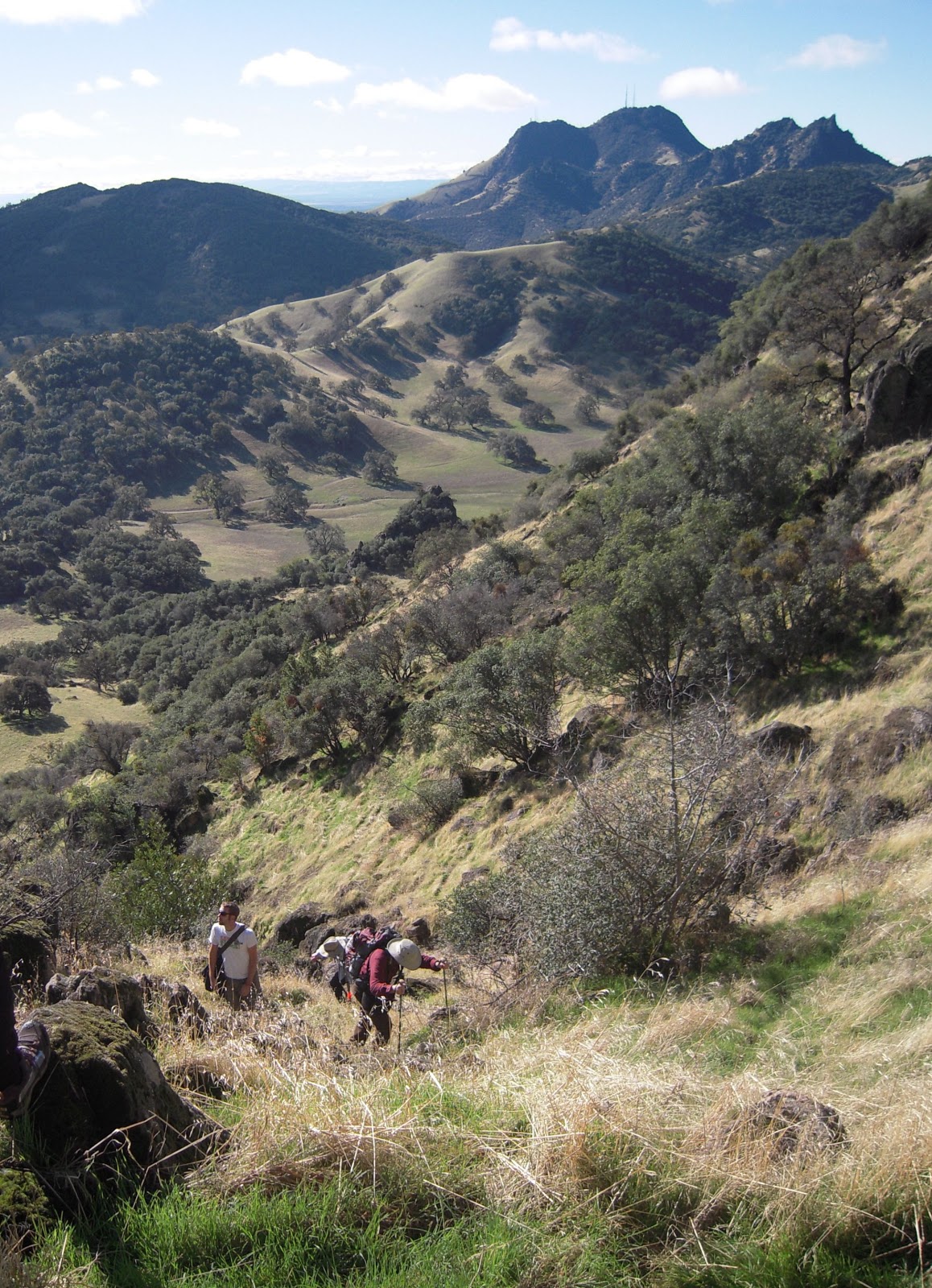
At the farthest end of the loop, you will find the tail into the Desolation Wilderness. Filled out the permit for your group and head up trail.  This trial becomes harder to follow.

Eventually we guessed which way to go and followed the creek. It becomes a scramble to the top. This is a good workout and the rock is slick in some sections.  After the long scramble, hike is easier to the lake.  The weather was a surprisingly warm, 90 in Strawberry, but with a slight breeze is was a beautiful day for a hike.

We spent about an hour at the lake.  We returned to the parking lot at 2:30. The drive home slowed to a crawl for some reason around Placerville. 

Top of Horsetail Falls.

Horsetail Falls from a distance.
Horsetail Falls near top

The water on its way to the falls.

Water before the falls.

Ropi Lake.

Another view of Ropi Lake.

Sunday, September 5, 2010

Grouse Ridge Lookout

On Saturday, September 5, 2010, I did the Grouse Ridge hike with the Sacramento Trail Mix Hiking Meetup.  This is located about a two hour drive from Sacramento in the Tahoe National Forest.  The hike takes you around a number of lakes and follows some old mining trails.  The end point of the hike is a visit to the Grouse Ridge Lookout.  This Forest Service fire lookout was built in 1923, but has been vacant and vandalized since the 1970s.  You cannot go into the building, but that may change as a group is looking into restoring the building. You can walk around the balcony, which was quite windy.  The Lookout provides a beautiful vista at an elevation of 7707 feet.

Island Lake from the Grouse Ridge Trail.
A view from Grouse Ridge.
The Trail up to Grouse Ridge Lookout
Outhouse at the end of the world (or at least Grouse Ridge.)

Someone in the group posted this video of the trip.